
|
|
The background investigation is essentially a "detective investigation" for information on the stream and includes the following steps:
Stream headwaters, length, tributaries, final stream destination, and watershed boundaries are best determined through maps. Of greatest value are U.S. Geological Survey 7 1/2- minute topographic maps (on a 1:24,000 scale where 1 inch = 2,000 feet). At varying degrees of resolution, they depict landforms, major roads and political boundaries, developments, streams, tributaries, lakes, and other land features. Sporting goods stores and bookstores often carry these maps, especially for recreational areas that are likely to be hiked or camped. The maps can also be ordered through the U.S. Geological Survey (see Obtaining USGS Topographic Maps).
Road, state, and county maps might also prove helpful in identifying some of these stream and watershed features. Hydrologic unit maps, also available from the U.S. Geological Survey but at a 1:100,000 scale of resolution (less detail than the 7 1/2-minute maps cited above), might also help you determine hydrologic watershed boundaries. Atlases and other reference materials at libraries can prove helpful in determining facts about population in the watershed.
Land uses in the stream watershed might also be depicted on maps such as those discussed above. You will verify this information in the second half of the watershed survey, when you are actually in the field observing land around the stream. Information from maps is particularly useful in developing a broad statement about general land use in the stream watershed (e.g., land use in the hypothetical Volunteer Creek watershed is 60 percent residential, 20 percent parkland/recreational, and 20 percent light industrial).
The U.S. Geological Survey's Earth Science Information Centers can provide you with a catalog of available USGS topographic maps, a brochure on how to use topographic maps, and general information on ESIC services. Contact the main ESIC office at:
507 National Center 12201 Sunrise Valley Drive Reston, VA 22092 1-800-USA-MAPS You can obtain a free USGS Indexing Catalog to help you identify the map(s) you need by calling 1-800-435-7627. If you know the coordinates of the map you need, you can order it directly from:
Branch of Information Services Box 25286 Denver, CO 80225 Place your order in writing and include a check for $4.00 per map plus $3.50 for shipping and handling. The ESIC can also refer you to commercial map distributors that can get you the topographic maps sooner, for a higher fee. USGS topographic maps might also be available from sporting goods stores in your area. |
Other sources of information include:
Especially in older metropolitan areas, combined sewers are also potential discharges. Combined sewers are pipes in which sanitary sewer waste overflow and storm water are combined in times of heavy rain. These combined sewers are designed to discharge directly into harbors and rivers during storms when the volume of flow in the sewers exceeds the capacity of the sewer system. The discharge might include raw sanitary sewage waste. Combined sewers do not flow in dry weather. Maps of sewer systems can be obtained from your local water utility.
The state or local environmental agency should also be able to provide location information on other potential pollution sources such as landfills, wastewater treatment plants, and stormwater detention ponds.
Current uses of the stream are established in state water quality standards, which specify what the uses of all state waters should be. These uses can include, for example, cold water fisheries, primary contact recreation (swimming) and irrigation. The state also establishes criteria or limits on pollutants in the waters necessary to maintain sufficient water quality to support those uses, as well as a narrative statement that prohibits degradation of waters below their designated uses.
Section 305(b) of the Clean Water Act requires states to report to the U.S. Environmental Protection Agency on the designated uses of their waters, the extent of the impairment of those uses, and the causes and sources of impairment. This information is kept on file at the state water quality agency. While state reports cannot specify water uses and degree of impairment in all individual streams in the state, they are a good starting point. Write to the state water quality agency for its biennial water quality (section 305(b)) assessment.
You might also be able to obtain a copy of your state's water quality standards or establish contact with a water quality specialist who can give you information on standards for your stream. Again, information on actual water uses will be verified and detailed once you walk the stream during the visual assessment portion of your watershed survey.
Historical land uses and the history of the stream might take some legwork to uncover. Local historical societies, libraries, and newspaper archives are good places to start. Look for historical photos of the area and stories about fishing contests, fish kills, spills, floods, and other major events affecting the stream and its watershed. County or town planning offices might be able to provide information on when residential developments were built and when streams were channelized or diverted. State and local transportation agencies might have records on when highways and bridges were built. State environmental regulatory agencies have records of past or current applications to modify stream hydrology through dredging, channelization, and stream bank stabilization.
Long-time residents are another invaluable source of information on the history of your stream. People who fished or swam in your stream in their youth might have witnessed how the stream has changed. They might remember industries or land use activities of the past such as mines or farms that could have affected the stream. They might have tales to tell about fish they once caught or floods that led to channelization and dams. Assembling such oral histories is a particularly good activity for schoolage volunteers.
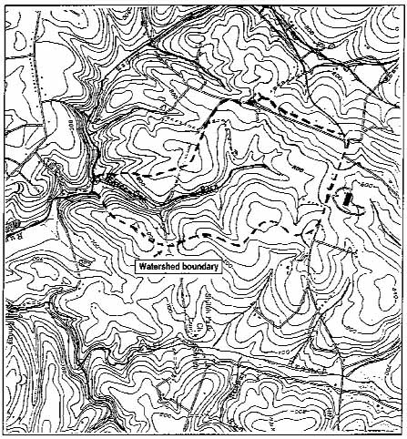 Figure 3.1 A topographic map with a delineated watershed Volunteers should learn to read a topo map to learn about the natural and cultural features of their study stream's watershed. |
Once you've obtained topographic maps of your area, follow these steps to draw your watershed boundaries:
|
|
From: Eleanor Ely, Delineating a Watershed,
The Volunteer Monitor 6(2), Fall 1994. |
The investigation might emphasize those aspects which are most important to the volunteers or the watershed, or it might include all the resources and tools listed above. In any case, rely on the interests of the volunteers in designing and conducting the background investigation, and divide duties among different volunteers.
Once the investigation has been conducted, either the program coordinator or an interested volunteer should compile the information collected and present it to other volunteers in written form or at a programwide meeting. At a minimum, key information on land uses, water uses, watershed boundaries, and dischargers should be maintained in written form for program use and for volunteers who might join the program at a later date. Maps, photographs, and other information on previous water quality studies in the watershed will be of particular value to the program over time.
Historic and current aerial photographs can be obtained from local, state, and federal governments, as well as private firms. Try planning offices, highway departments, soil and water conservation districts, state departments of transportation, and universities. Federal sources of aerial photographs include:
|
EPA Home | Office of Water | Search | Comments