| |
|||
|
|
|
Related Products: Society for Amateur Scientists
|
![]() Sponsored by:
Sponsored by:

How to Obtain Aerial PhotographsUSGS Fact Sheet 081-99 (April
1999)
The U.S. Geological Survey (USGS) maintains an informational data base of aerial photographic coverage of the United States and its territories that dates back to the 1940's. This information describes photographic projects from the USGS, other Federal, State, and local government agencies, and commercial firms.
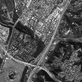
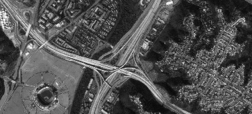
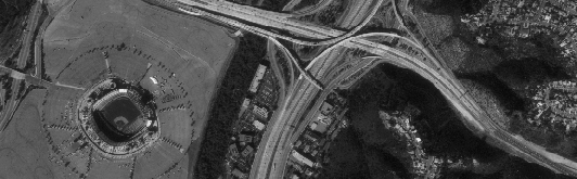
The pictures on this page show a part of a standard 9- by 9-inch photograph and the results obtained by enlarging the original photograph two and four times. Compare the size of the Qualcomm Stadium, Jack Murphy Field, in San Diego, Calif, and the adjacent parking lot and freeways shown at the different scales.
In this 4X (36 x 36 inch) enlargement of the same photograph, at a scale of 1:10,000, 1 inch on the photograph represents 833 feet on the ground. USGS Earth Science Information Center (ESIC) representatives will assist you in locating and ordering photographs. Please submit the completed checklist and a marked map showing your area of interest to any ESIC. Information For information on these and
other USGS products and services, call 1-888-ASK-USGS, use the Ask.USGS
fax-on-demand system, which is available 24 hours a day at 703-648-4888,
or visit the general interest publications Web site on mapping, geography,
and related topics at http://mac.usgs.gov/mac/isb/pubs/pubslists/index.html.
Reprinted from:
|